Cobra Dane Power Cutback Cancelled (April 10, 2013)

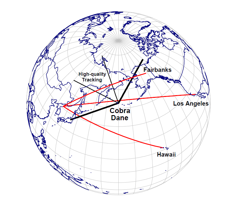
As discussed in a recent post, as a result of sequestration, the Air Force had planned to reduce operations at several large radars used for space surveillance and ballistic missile defense.  One of the radars expected to have its operations cut back was Cobra Dane, a large phased-array radar on Shemya Island at the western end of the Aleutians.  According to General William Shelton, Commander of the Air Force Space Command, as a cost saving measure, the plan had been to cut the radar’s operation to one-quarter power for the rest of the year, which would save about $5 million.[1]  This reduction would likely be accomplished by reducing the radar’s duty cycle (the fraction of the time it emits radar energy) from 6% to 1.5%, as has been done previously

Cobra Dane, originally built to gather intelligence on Soviet ballistic missile tests, is now also part of the U.S Ground-Based Midcourse Defense (GMD) system, which has 30 interceptors deployed in Alaska and Hawaii.  It is also an important part of the U.S. space surveillance system, as it can detect and track objects in low Earth orbit down to sizes of about 5 centimeters, significantly smaller than any other radar in the network.  Shelton stated that this cutback in power would have temporarily eliminated the radar’s space surveillance role, but that the U.S. had ways to compensate for this loss.  Prior to 2003, Cobra Dane had operated at one-quarter power (also for cost reasons), with the ability to return to full power in 30 seconds if a missile test occurred.  When full power operation was restored in March 2003, Cobra Dane was able to begin operating a high-elevation space surveillance “fence,” significantly  enhancing the space surveillance system’s capabilities.

However, as a result of the ongoing tensions with North Korea, this planned cutback in Cobra Dane’s operations has been cancelled.  This reversal is unlikely to affect the other two systems that had been scheduled to have their operations cut back, the large phased array radar at Cavalier Air Station in North Dakota and the Air Force Space Surveillance System at multiple sites in the southern United States, as neither is part of the current U.S. missile defense system.


Sequestration and U.S. Missile Defense/Space Surveillance Radars (February 25, 2013)

According to the Air Force, if sequestration goes into effect, it would have to make cuts in radar operations that would have the effect of “significantly impacting national missile defense, space situational awareness, and the intelligence community.”[1]  Specifically, radar operations at Cavalier Air Force Station in North Dakota and at Earecksen Air Station, Alaska and operation the Air Force Space Surveillance System (AFSSS) would be reduced from 24 to 8 hours per day.

Would such reductions actually seriously impact U.S. missile defenses?

CobraDaneCoverage2

Coverage of the Cobra Dane radar at Earecksen Air Station, Shemya Island, Alaska.  Figure from Union of Concerned Scientists, Technical Realities, p. 37.[2]

The large phased-array PARCS (Perimeter Acquisition Radar Attack Characterization System) radar at Cavalier, which was originally built part of the Safeguard Anti-ballistic Missile System, is now used for missile attack warning and space surveillance.  Earecksen Air Station on Shemya Island at the western end of the Aleutians is the home of the Cobra Dane, a large-phased array L-band radar originally built to gather intelligence on Soviet missile tests, but which is now also used for missile warning, missile  defense and space surveillance.  The AFSSS is a radar “fence” stretching across the southern United States that detects satellites as they pass over it, and is a dedicated component of the U.S. Space Surveillance Network (SSN).

In terms of missile defense, the impact of these temporary (presumably) cutbacks in radar operations seems pretty minimal.  PARCS is not part of the current GMD national missile defense system, and the AFSSS does not have (and cannot be given) any ballistic missile defense capabilities.  While Cobra Dane has been part of the GMD system since the GMD was first declared operational, because of its poor orientation it has never participated in an intercept test.  While Cobra Dane can potentially provide much higher resolution radar data than the Pave Paws radar in California, it can only do so within a narrow region within 22 degrees of its boresite, which a missile from North Korea towards the U.S. west coast would spend little if any of its trajectory within (as shown in figure above). Nor does removing these radars from the early warning network open up any gaps in the coverage provided by the five BMEWS and Pave Paws early warning radars.

The impact on space surveillance seems potentially much more significant.  Cobra Dane can detect and track smaller objects in low earth orbit than any of the SSN’s other sensors (down to as small as about 5 cm, although it only tracks a small fraction of such objects).  It has this small-object capability largely because it operates at a higher frequency (about 1.3 GHz) than other seven large phased-array radars in the SSN, all of which operate in the UHF band at about 440 MHz.  PARCS, although not ideally situated for space surveillance (it is in North Dakota, facing north) is, along with the FPS-85 radar in Florida, one of the two most powerful of the large UHF phased-array radars in the SSN.  The AFSSS, while it cannot detect objects much smaller than about 30 cm in diameter, nevertheless produces thousands of measurements every day on space objects that pass through its radar fence.


[1] Maggie Ybarra, “Air Force Lists Programs that Sequestration Cuts Would Hit Hardest,” Inside Defense SITREP, February 19, 1993.

[2] Lisbeth Gronlund, David C. Wright, George N. Lewis, and Philip E. Coyle, Technical Realities: an Analysis of the 2004 Deployment of a U.S. National Missile Defense System (Cambridge, Mass. Union of Concerned Scientists, 2004).  Available at:  http://www.ucsusa.org/assets/documents/nwgs/technicalrealities_fullreport.pdf.

Wideband Imaging Radars Summary Table (September 10, 2012)

The table below summarizes the main characteristics (where these are known or can be estimated) of the wide-band imaging radars in the Space Surveillance Network.  See the posts on the individual systems for details.  (Click on the Table for a more legible version)

Space Surveillance Sensors: The Haystack HUSIR Upgrade (September 9, 2012)

The X-band Haystack Long Range Imaging Radar (LRIR) is currently undergoing an upgrade that will add a W-Band (92-100 GHZ) imaging capability for satellites in low earth orbits.  The upgraded system will be known as the Haystack Ultrawideband Satellite Imaging Radar (HUSIR).  The W-band capability will provide a bandwidth of 8 GHz, eight times greater than the previous X-band capability, and is expected to be operational in 2013.  The previous X-band capability, which provided an imaging resolution of about 25 cm out to geosynchronous orbit, will be retained and is expected to be back in operation in 2012. 


Installation of the new Haystack antenna (photograph from Lincoln Laboratory 2011 Annual Report, p. 27).

  (more…)

Space Surveillance Sensors: Some Additional Background on GEODSS’ CCD Detector (August 30, 2012)

Modern systems for visible detection and tracking of space objects, such as the Ground-based Electro-Optical Deep Space Surveillance (GEODSS) system are typically built around a telescope equipped with a charge-coupled device (CCD) detector.  This post follows up on the August 20 post on GEODSS by providing some additional information of how the GEODSS CCD operates. In the next GEODSS post, I will make a rough estimate of GEODSS detection capability (in terms of the faintest object it can detect) based on the available information about the telescope and its CCD detector, and compare this to published values.


Figure 1. A GEODSS camera.[1] 

  (more…)

Space Surveillance: The Visual Brightness and Size of Space Objects (August 21, 2012)

 In yesterday’s post on the GEODSS optical space tracking system, I frequently referred to the visual magnitudes of space objects and to the object sizes corresponding to those brightnesses. This post briefly discusses brightness and visual magnitudes and the standard procedure for assigning a size to an object of a given magnitude.

(more…)

Space Surveillance Sensors: GEODSS (Ground-based Electro-Optical Deep Space Surveillance) System (August 20, 2012)

The GEODSS (Ground-based Electro-Optical Deep Space Surveillance) System is the United States’ primary deep space tracking system.  The Deep Stare upgrade of GEODSS, carried out in about 2003-2005, greatly increased the capabilities of the system.  GEODSS uses a total of nine large telescopes at three different locations to track space objects by using reflected sunlight, (and thus can only operate at night and when not cloudy).  It can likely detect objects with sizes under 0.5 meters in geosynchronous orbits.  GEODSS provides about 60% of all the SSN’s deep space (orbits with periods greater than 225 minutes) observations and nearly 80% of all geosynchronous observations.[1]   There are over two hundred GEODSS-tracked objects that are not tracked by any other sensor.[2]

A GEODSS Telescope.[1]

(more…)

Space Surveillance Sensors: Haystack Auxiliary Radar (July 21, 2012)

The Haystack Auxiliary Radar (HAX) is a wideband radar located at the Lincoln Space Surveillance Complex near Boston, the same site as the Haystack imaging radar and the Millstone Hill tracking radar.[1]  As a contributing sensor in the Space Surveillance Network (SSN) it is used for imaging near-earth orbit satellites, and it is also an important sensor for scientific studies aimed at characterizing the near-earth space debris environment.


HAX Radar Under Construction (image from: http://www.orbitaldebris.jsc.nasa.gov/measure/images/radar_dome.jpg)

(more…)

Space Surveillance Sensors: Millimeter Wave (MMW) Radar (June 19, 2012)

Millimeter Wave (MMW) Radar

The Millimeter Wave (MMW) radar is a Ka-band (35 GHz) and possibly W-Band (95 GHz) imaging radar at the Kwajalein Atoll on the Pacific. It is a collateral sensor in the Space Surveillance Network (SSN).  It has recently been upgraded to a 4 GHz bandwidth, giving it a range resolution of about six centimeters.  It is currently the highest resolution imaging radar in the SSN (although it will be surpassed by the W-band upgrade to the Haystack radar when this becomes operational, likely in 2013).   


Photograph from: http://www.ll.mit.edu/publications/MITLL_2011_annual_report.pdf

(more…)

Space Surveillance Sensors: Globus II Radar (June 1, 2012)

Globus II

The Globus II is a large X-band dish radar located at Vardo in northern Norway (70.37˚ N, 31.13˚ E).  It is a dedicated sensor in the SSN and is used for tracking deep space objects, including objects in geosynchronous orbits, and for wide-band imaging of space objects.

The Globus II overlooking the town of Vardo (photograph from: http://barentsobserver.com/en/node/22234)

  (more…)