Globus II
The Globus II is a large X-band dish radar located at Vardo in northern Norway (70.37˚ N, 31.13˚ E). It is a dedicated sensor in the SSN and is used for tracking deep space objects, including objects in geosynchronous orbits, and for wide-band imaging of space objects.
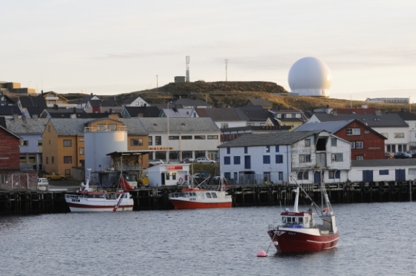
The Globus II overlooking the town of Vardo (photograph from: http://barentsobserver.com/en/node/22234)
Background
Originally known as HAVE STARE (AN/FPS-129), the radar became operational in 1995 at Vandenberg Air Force base in California.[1] While there, it observed several intercontinental ballistic missile (ICBM) flight tests a as well as two non-intercept tests of the kill vehicle for U.S. national missile defense interceptor then under development (IFT-1A and IFT-2).
Beginning in late 1998, HAVE STARE was dismantled and moved to Vardo, and renamed Globus II and appears to have become operational in about 2003. A radar named Globus, had been operated since the 1960s by Norway at Vardo, in cooperation with the U.S. Air Force, and was used to monitor Soviet and Russian ballistic missile flight tests.
Outside observers have argued that Globus II is likely to be used to gather information on Russian ballistic missile tests, and that such information could be useful for ballistic missile defense. However, official Norwegian government statements stated that the radar would be used operated by only be Norwegian personnel and would be used to track and monitor objects (including space debris) in space, research and development, and “Surveillance of the Norwegian area of interest, including the technical gathering of intelligence.”[2]
Technical Characteristics
Few technical details about the Globus II are publicly available. The radar has a peak power of 200 kW and operates at X-band (9.5-10.5 GHz).[3] It has a 27 m diameter antenna in a 35 m diameter radome. Its beamwidth is less than 0.1˚. (λ/D = 0.0011 = 0.06˚)
Operations
Globus II “provides the most accurate tracking of any space surveillance radar.”[4]
A 2001 briefing slide indicated that the Globus II was expected to track about 100 deep space objects daily and to provide imagery on three deep space objects per day.[5]
The radar is currently undergoing a service life extension program to extend its operating life to 2030.
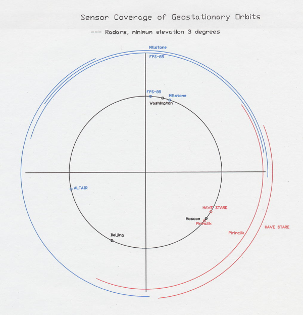
Although the Globus II radar is quite far north, it is still capable of viewing more than a 90˚ arc of the geosynchronous belt. Together with its location at about 31˚ E, this allows it to completely, or nearly completely, fill in the gap in geosynchronous radar tracking coverage between the Millstone Hill radar in Massachusetts and the ALTAIR radar at Kwajalein (This sector used to be covered by the radar at Pirinclik in Turkey, which is no longer in use.) See the figure below.
The figure above shows angular coverage of the geosynchronous belt by tracking radars of the U.S. Space Surveillance Network (SSN), as viewed from below the south pole looking north (radial distances are not to any scale). The inner circle shows the angular location (longitude) of the radars, and the outer circular arcs show their angular coverage of the geosynchronous belt. A minimum elevation angle of 3 degrees is assumed for the radars. Shown in blue are the coverages for the Millstone Hill (Massachusetts), FPS-85 (Florida) and ALTAIR (Kwajalein) radars, all of which are discussed in previous posts. The coverages of the Globus II (Have Stare) and the former FPS-79 radar at Pirinclik, Turkey are shown in red.
[1] For background on the GLOBUS II and the controversy over its deployment to Norway, see: Inge Sellevag, “Vardo Exposed,” The Bulletin of the Atomic Scientists,” March/April 2000, pp. 26-29; and Theodore A. Postol, “The Target Is Russia,” The Bulletin of the Atomic Scientists,” March/April 2000, pp. 30-35.
[2] “The Globus II Radar and Norwegian Surveillance Activities in the North,” statement by Norwegian Minister of Defense Eldbjorg Lower, February 25, 2000. Available at: www.fas.org./spp/military/program/track/0000225-hs1.htm.
[3] Erik Korsbakken, “Possible Use of GLOBUS II for Cooperative R&D,” available at; http://www.cdi.org/pdfs/Korsbakken.pdf.
[4] Richard F, Colarco, “Space Surveillance Network Sensor Development, Modification, and Sustainment Programs,” 2009 AMOS Conference, available at: http://www.amostech.com/TechnicalPapers/2009/Space_Situational_Awareness/Colarco.pdf.
[5] Gen H. McCall, Space Surveillance,” January 23, 2001. (Available at: http://www.fas.org/spp/military/program/track/mccall.pdf).

